Science Sunday – El Niño
Scientists warn an El Niño is likely coming that could bring scorching heat to Earth
From: Yahoo.com
Buckle up. The world’s most influential natural weather feature is shifting gears.
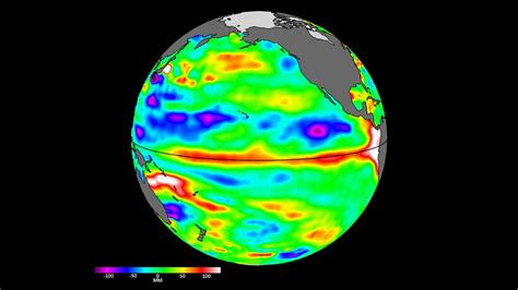
An El Niño is building along the equator in the eastern Pacific Ocean, and chances are above normal it will be a strong El Niño, the National Oceanic and Atmospheric Administration says. That could have dramatic consequences in the United States and around the globe this year and into next year.
Climate scientists are especially concerned about the potential for hotter temperatures. Given things already are warmer than normal, they say, a strong El Niño could send global average temperatures soaring to a record high.
El Niño is a natural climate pattern. It’s counterpart, La Niña, ended over the winter after three years of disastrous weather.
Ocean temperatures shockingly hot: Scientists aren’t sure what happens next.
The most recent ocean temperature in the El Niño region, the central and eastern tropical Pacific Ocean, was just 0.1 degrees Celsius from the threshold needed to declare an El Niño, Nat Johnson, with NOAA’S Geophysical Fluid Dynamics Laboratory, wrote in a blog post published Thursday.
But while the ocean appears ready, Johnson said, the tropical atmosphere remains in more neutral territory in the atmospheric indexes the scientists watch. But the signs are getting stronger, giving scientists growing confidence in an El Niño declaration by July, Johnson said. Chances for a strong El Niño are about 55%.
What is El Niño?
El Niño is a natural climate pattern in which surface sea water temperatures in the central and eastern tropical Pacific Ocean are warmer than average.

Its name means the Little Boy, or Christ Child in Spanish. El Niño originally was recognized by fishermen off the coast of South America in the 1600s with the appearance of unusually warm water in the Pacific Ocean around Christmas.
The entire natural climate cycle is officially known as El Niño – Southern Oscillation, called ENSO by scientists. The cycle swings between warmer and cooler seawater in a region along the equator in the tropical Pacific. La Niña is marked by cooler-than-average ocean water in the region.
The ocean was already warm even as the El Niño began to brew. the warming temperatures:
The ENSO cycle is the primary factor government scientists consider when announcing their winter weather forecast because it mainly influences our weather in the colder months.
During an El Niño winter, the southern third of the U.S. typically experiences wetter-than-average conditions, while the northern third sees enhanced chances of below-normal precipitation, said David DeWitt, director of the
That could be important for states such as Washington, Oregon and Montana that get much of their annual precipitation in the winter, DeWitt said. El Niño also means increased chances for below-normal temperatures across the southern U.S. and above-normal temperatures in the northern third of the country.
Though El Niño means fewer storms and milder weather to the north, the threat of tornadoes is significantly greater in Central and South Florida, according to the National Weather Service.
During a La Niña, conditions flip, with colder and stormier conditions to the north and warmer, less stormy conditions across the south.
Rainfall in the southern U.S. and the west coast of South America can cause destructive flooding during El Niño, while drought conditions in the western Pacific have been associated with devastating brush fires in Australia.
El Niño also “tends to lead to an increase in vertical wind shear, which tends to reduce the number of hurricanes in the tropical Atlantic,” DeWitt said. Because the winds prevent hurricanes from building the vertical structure that helps them grow stronger, NOAA and other forecasters factor in El Niño when issuing seasonal hurricane predictions.
El Niño can increase the number of hurricanes that form in the eastern Pacific basin, however.
How bad will 2023 hurricane season be?
Although La Niña has been known for cooling global average temperatures, 2022 was still the sixth-warmest year in records that date back to 1880.
With an El Niño arrival, scientists expect to see a marked increase in global average temperatures.
“It turns out the tropical Pacific sea surface temperatures kind of act as a pacemaker for global surface temperatures,” DeWitt said. During El Niño events, global surface temperatures mirror temperature increases in the tropical Pacific.
, Adam Scaife, its head of long-range forecasting, said: “The current record for global temperature occurred in 2016 and it’s no coincidence that followed the last big El Niño. If we get a big El Niño at the end of this year then, we’re likely to break the record for global temperature in 2024.”
The Met Office has said an El Niño could at least temporarily push the global average temperature up to 1.5 degrees Celsius above pre-industrial temperatures, DeWitt said.
That 1.5-degree Celsius mark above the long-term global temperature is a level world leaders had hoped to avoid.
This article originally appeared on USA TODAY: